The Danish Geodata Agency and EOMAP Will Join Efforts in Mapping the Shallow Waters of Denmark
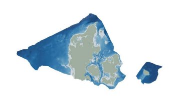
By using Satellite-Derived Bathymetry (SDB), the Danish Geodata Agency and EOMAP are joining forces to contribute to the European Marine Observation and Data Network (EMODnet) Bathymetry partnership, and to integrate the SDB data into the Danish Depth Model (DDM).
Using cutting-edge satellite technology, the cooperation will provide better mapping of shallow water areas lacking bathymetric coverage. This will also help improve the coverage of the DDM developed by the Danish Hydrographic Office, a part of the Danish Geodata Agency.
“Finding new ways to map shallow waters, where we only have very old data, and increasing the utilization of depth data for marine stakeholders and society is central in the goals of the Danish Hydrographic Office. Satellite technology shows great potential in this regard. We are therefore happy to contribute to this cooperation that benefits the users of both the DDM and EMODnet Bathymetry”, says Elizabeth Hagemann, Head of Office in the Danish Hydrographic Office.
“Denmark is particularly rich in shallow waters, with considerable parts mapped more than 100 years ago. For filling data gaps in large areas, SDB is widely approved as a very efficient technology. Together with existing bathymetric data, this cooperation project will thus help create a seamless shallow water grid of the Danish coastline and its hundreds of islands”, states Knut Hartmann, COO of EOMAP.
As an additional benefit for marine stakeholders, the project will also be embedded into the largescale European model by EMODnet Bathymetry.
“EOMODnet Bathymetry provides the harmonized bathymetric surface for all European waters. We foster new ideas and concepts which aim to provide better mapping of our waters. Therefore, we very much appreciate this co-operation and believe that the Danish grid – integrated into the next EMODnet Bathymetry release – will contribute improving the accuracy of our product and will fulfill the expectations of our users”, explains Thierry, Schmitt, Coordinator EMODnet Bathymetry.
About EMODnet Bathymetry
EMODnet Bathymetry provides a service for viewing and downloading the best available harmonised Digital Terrain Model (DTM) for the European sea regions, together with a range of other bathymetric data, products, and services. For more information, see https://emodnet.ec.europa.eu/en/bathymetry.
About Danish Geodata Agency
The Danish Geodata Agency produces and compiles geospatial data about the sea. The agency makes data, nautical charts and other maritime products for Danish and Greenlandic waters available to allow for safe navigation and public administration at sea.
About EOMAP
EOMAP is an earth observation and software solution company. With its headquarters in Munich and global affiliations, EOMAP provides data, software, and intelligence ‘powered by space' to industry, governments, and academia. EOMAP has received various awards for technological excellence and keeps partnering in European innovation projects. The team’s overarching goal remains to support the sustainable management of the world's key resource: water.
Be updated with Oceanology International and follow us on social media
Looking for something else?
For further information, please contact:
Mike Enser, Marketing Manager
Oceanology International
Tel: +44 (0)20 8439 5226
[email protected]
Karen Bartlett
Saltwater
Tel: +44 (0)1202 669244
[email protected]
About the Oceanology International Portfolio
Oceanology International – Connecting the global ocean technology, engineering and science communities
Oceanology International (Oi) is the global forum where the ocean industry, academia and government connect to discover innovative solutions from the ocean technology and marine science communities to improve strategies for exploring, protecting and sustainably operating in the world’s oceans and waterways. Held at ExCeL London, Oi brings together ocean professionals, facilitates ocean connections and showcases ocean innovation and technology.
www.oceanologyinternational.com
Oi exhibition and conference incorporates various events and features, including:
- COAST – NEW Coastal and Shallow Water focus
New for 2026, COAST at Oceanology International offers a unique platform to showcase their solutions, technologies, and expertise to a highly targeted and engaged audience from across the global coastal and shallow water community.
- Conference Program – Diving deep into the realm of ocean science and marine technology
Featuring a compelling line-up of industry-leading speakers, the full strategic Oi Conference Programme encompasses a diverse range of Technical Sessions and Ocean Futures-focused content across different conference locations. World-class scientists, thought leaders and innovators in the vanguard of the global ocean technology community will converge to bring insightful and original content.
- Ocean Futures Theatre – Meeting future ocean technology needs
Thought leaders from industry, academia and government come together to discuss meeting future ocean technology needs in line with market developments and new ocean enterprise strategies. Held in the keynote Ocean Futures Theatre, it features panel discussions and strategic debates on topics including Transitioning the Ocean Economy, Sustainable Offshore Operations, BlueTech Investment and Future Talent/Careers.
- Dockside Demonstrations
Oceanology International’s dockside activity is a hallmark feature of the event, offering visitors live, in-water demonstrations of the latest ocean technology and equipment. Attendees have the unique opportunity to see cutting-edge remotely operated vehicles (ROVs), autonomous systems, sonar, imaging, and hydrographic survey tools in real-world action, guided by experts. These demonstrations take place at the Royal Victoria Dock, where multiple brands and vessels showcase novel capabilities—allowing participants to closely observe technological innovations and interact with operators, all with the goal of experiencing emerging solutions for marine and subsea applications firsthand.
About RX
RX is a global leader in events and exhibitions, leveraging industry expertise, data, and technology to build businesses for individuals, communities, and organisations. With a presence in 25 countries across 41 industry sectors, RX hosts approximately 350 events annually. RX is committed to creating an inclusive work environment for all our people. RX empowers businesses to thrive by leveraging data-driven insights and digital solutions. RX is part of RELX, a global provider of information-based analytics and decision tools for professional and business customers.
For more information, visit www.rxglobal.com.
About RELX
RELX is a global provider of information-based analytics and decision tools for professional and business customers. RELX serves customers in more than 180 countries and has offices in about 40 countries. It employs more than 36,000 people over 40% of whom are in North America. The shares of RELX PLC, the parent company, are traded on the London, Amsterdam and New York stock exchanges using the following ticker symbols: London: REL; Amsterdam: REN; New York: RELX.
*Note: Current market capitalisation can be found at https://www.relx.com/investor.